The future of weather forecasting is in your back pocket.
Joel Gratz and his team of microforecasters provide outdoor adventurers with invaluable weather data for finding the best snow and avoiding the worst storms.
Full Transparency
Our editorial transparency tool uses blockchain technology to permanently log all changes made to official releases after publication. However, this post is not an official release and therefore not tracked. Visit our learn more for more information.
Thousands of feet above the tree line on high mountain peaks, weather changes fast. Avalanches, lightning strikes, freezing temperatures and high winds—conditions so extreme even trees can’t grow. But every year, thousands of outdoor enthusiasts brave these austere environments, hiking, biking, skiing and snowboarding—chasing the thrill of remote alpine trails and virgin powder.
One man, with his team of microforecasters, is revolutionizing the science behind snow forecasts and weather reporting by using public data and an intimate knowledge of high mountain microclimates to deliver some of the most precise weather reporting in modern history. It can make the difference between being on the slopes when the perfect snowfall hits and being left exposed on a 14,000-foot (4,000 meter) peak when a storm rolls in.
That man is a meteorologist and powder hound, one who doesn’t go to work when over 6 inches of fresh snow lie on the slopes: Joel Gratz.
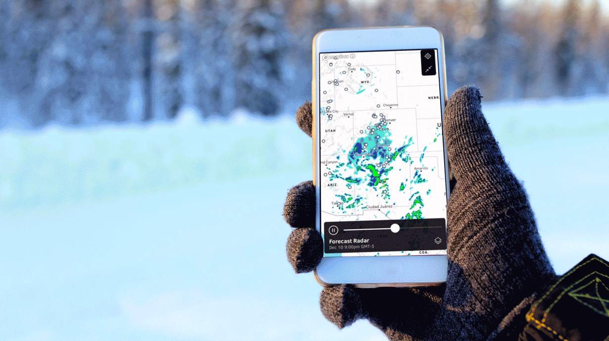
Joel has transformed an email newsletter into the OpenSnow and OpenSummit apps to provide more than 3 million outdoor enthusiasts of every kind with a tailored a snow forecast and weather report that covers everything from snow depth, to trail conditions, likelihood of lightning and predictive air quality after a wildfire.
Meet the Snow Geek.
“Most meteorologists get into weather when they’re very young due to some kind of weather event, like a tornado or hurricane,” Joel says. “I’m no different.”
When he was 4 years old, Joel’s parents took him to Shawnee Mountain in Pennsylvania to ski. He was hooked from the moment he saw the snowcapped hills. Before he was even in elementary school, Joel was searching for weather data to figure out if it was going to be cold enough for snow at his favorite mountain. “That was the beginning of my lifelong obsession with the weather,” he says.
Joel received his B.S. in Meteorology from Penn State, an MBA and a master’s in environmental science from the University of Colorado Boulder, and spent his summers hiking fourteeners—mountain peaks over 14,000 feet—and winters chasing deep powder.
As a trained meteorologist, when Joel planned his outdoor adventures to summit nearby peaks, he scoured weather models for days to determine which day had the lowest chance of lightning, which hours to avoid, which mountain ranges seemed safest.
But he knew that when most people planned to hike or ski a 14,000-foot mountain, they were simply typing the name of a nearby mountain town into a weather app, seeing a 20% chance of afternoon storms and assuming that was good enough. “But traditional weather reporting doesn’t work well in the big mountain areas.” Joel says.
“In cities,” he says, “it’s pretty normal for the area to generally get about the same amount of snow. It might range slightly from one side of the city to the other. But in the mountains, it’s very possible for one mountain 5 miles away to get two or three times more snow than another.”
“I had access to more data than most people did. And that just felt wrong. I didn’t want people to have to get a degree in meteorology to feel more confident when hiking in higher elevations or skiing big mountains.”
OpenSnow: Find the good.
So in December 2007, Joel wrote an email snow forecast to 37 friends, giving them his take on where and when to find the best snow that day. The email list grew organically, with friends forwarding it to friends, and in four years Joel had a large enough following to quit his full-time job and start OpenSnow.
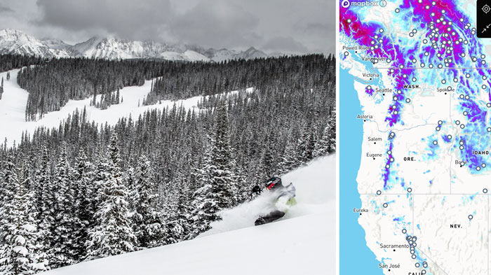
Today, OpenSnow still delivers a “Daily Snow” snow forecast email newsletter, but Joel has assembled a team of 20 local experts across the U.S. and Canada who provide uniquely precise reports on nearly 30 geographic microregions from the Canadian Rockies to the Appalachians.
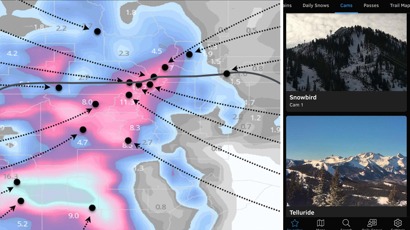
In the app, all-access users can see maps for snow depth, temperature and avalanche risk; snow forecasts for several days out; snowpack graphs and analysis; trail maps for 100+ resorts; and live-feed cams from resorts across the world, including Chamonix, France; Hakuba, Japan; and Lech, Austria.
“We’re bringing all of the snow forecast information into one easy-to-see spot,” Joel says.
For pro skier and mountaineering guide Chris Davenport, who spends more than 300 days a year in the mountains, OpenSnow provides an invaluable daily report. “Taking that science-based approach first thing in the morning for me is really important to my decision-making process, whether I’m with a film crew, or I’m with clients, or I’m just going out there to ski with my friends or family. Whatever it is, I’ve got that information in the back of my head and I’m not flying blind.
“Sometimes if I can’t decide if I should go to this mountain or that one, and both are looking pretty good, Joel will come back and say, ‘Actually, based on the wind direction and the temperature and the timing, this one looks much better.’ To have that bespoke forecasting in your back pocket, it’s pretty unprecedented. It just gives you a sense of security and confidence.”
OpenSummit: Avoid the bad.
“With OpenSnow, our snow forecast is trying to help you find those very short weather windows where there’s amazing snow,” Joel says. “OpenSummit is the complete opposite. We’re trying to help you avoid the very short weather windows where it’s not safe or comfortable to go hiking or biking, especially at higher elevations.”
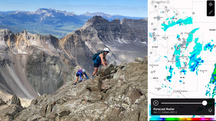
Originally, OpenSummit was born from the desire to help outdoor adventurers understand lightning risks and plan around them. “Typically, if you’re in town or at a park,” Joel says, “and you get a storm alert on your phone, you can just get in your car or go home. But if you’re hiking above the treeline—10,000 feet [3,000 meters] or higher—oftentimes exposed for hours, and a thunderstorm rolls in, you have very few options to attain safety. So you want to be really sure that there’s no lightning coming.”
This past summer, it wasn’t just lightning on the minds of hikers. 2020 was a catastrophic year for wildfires, prompting preparation and responses from the public and private sector, including Verizon. In California, well over 4 million acres [1,618 hectares] have been burned, making it the state’s worst wildfire season in history, and is still going. In Colorado, three of the state’s largest wildfires ever took place over the summer. Oregon had its most destructive wildfire season, burning over 1 million acres and destroying thousands of homes. Smoke from the fires traveled across the country and forced some people to stay inside—in a time when many were looking to the outdoors to escape the confines of quarantine.
So OpenSummit published maps of wildfire smoke. “And not just where it is now, but where it will be in the future,” Joel says. “Which is quite unique, because there’s a few sites that show current air quality, but they don’t show what’s going to happen over the next 12 to 18 hours.
“Just like you, we were wondering, ‘Should I go on a bike ride with my kid this afternoon or not?’ And so by taking that government science—like wind speed, fire location, smoke particles in the air, fire growth forecasts—we have a pretty good way to figure out where the smoke is going.”
Global cooperation for local exploration
To provide all that information, Joel’s team pulls data from international weather centers like NOAA (National Oceanic and Atmospheric Administration) to get precipitation, temperature and wind forecasts at every elevation.
“Virtually every weather company in the world has access to the same data,” Joel says. “Most of it is funded by our tax dollars and tax dollars around the world. Really, it’s an amazing story of global cooperation. There’s no ability to predict weather without having a global understanding of temperatures, winds, humidity, precipitation. So governments around the world coordinate and share this data to create forecast models.”
Joel’s team reorganizes the raw data to make it fit the mountains and then homes in on a few key elements.
“Focus is our secret sauce. Traditional weather apps for the average user aren’t going to focus on things like snow precipitation, high elevation and wind because most people don’t care about it, they just want to know if it’s going to be raining on the way to work. But there are a lot of people that do, and that’s our crew.”
Niche weather reporting
Cheaper computing, advanced technology, and smartphones in every pocket have coalesced to allow companies like OpenSnow to bring professional tools to their audience. “Even just 15 years ago, weather data was transmitted by satellite, Joel says. “So if you wanted all this specialized, raw data from the governments, you had to set up a satellite dish and a satellite connection. That sounds laughable because now we just go to a website, download the data, adjust it, store it in the cloud, then send a detailed snow forecast to your phone.
“Now, it’s much easier to disseminate data from the government to us as a weather company. And then from us to people on their phones. It has opened the door for as many weather apps as there are niches for people to get specialized weather.”
Apps like Surfline Surf Weather Forecast help surfers navigate swells, and apps like AyeTides help sailors move through oceanic currents.
A scientifically literate public
Being able to give such accurate and timely information regarding weather was a goal of scientists decades ago, Joel says, and now it’s been achieved.
“We take for granted that we know that storms are coming days or even a week ahead. People look at advances in medicine, technology and computing, which are amazing and incredible, but meteorology is right up there. And we want to be able to share that.”
“We always felt that people would have a better time outside if they knew just a little bit more about the science that underpins their adventure, whether that be avoiding lightning on a fourteener here in Colorado or diving right into a blizzard on the slopes of North Carolina.
Want to amplify Joel Gratz's impact? Share this story with your community.
“We’re not trying to turn people into meteorologists—although that has happened,” Joel says. But the better people understand earth sciences and the environment, he says, the more likely they are to go outside and do whatever it is that makes them happy and healthy.
2020 has been noted as challenging year in many ways. Learn how the Verizon Response team stands ready alongside government agencies, emergency responders, nonprofits and communities on a 24/7/365 basis to provide critical support during a crisis.
Know someone who's creating a positive impact using technology and connectivity? Send us a message at story.inquiry@verizon.com. They could be next in our story series.